Skip to content

Peloponnese Castles

Peloponnese Castles

Castles Around The Peloponnese You Need To See

Peloponnese is the largest peninsula in Greece and consists of seven prefectures: Achaia, Ilia, Messinia, Arcadia, Laconia, Argolida and Corinthia. Each county has a brilliant history that begins from prehistoric times and all of them have unique natural beauty and landscapes. The Peloponnese, possessing a strategically important geographic location in the eastern Mediterranean, has experienced in its long history the continuous political and social changes. Many raiders have tried and some have succeeded in conquering it. 

A brief introduction to the Peloponnese peninsula

Significant monuments, unique settlements, scenic cities and charming castles, as well as natural beauties such as mountains and forests, rivers and caves, beautiful beaches with rocky and lacy coasts, make the Peloponnese a region that is an ideal destination all the time.

The Peloponnese in its long history over the centuries has played a leading role in the political developments of the Greek nation and, more broadly, of the Mediterranean. From the Mycenaean times to the modern times, it has always been at the center of interest not only for Greeks, but also for forces outside Greece, especially in post-Christian times. Romans, Goths, Slavs, Normans, Franks, Venetians, Spaniards, Turks and Egyptians that left their traces indelibly through monuments that bring to life stories of war, conquest, but also, in some cases, civilization. 

Many raiders have tried and some have succeeded in conquering it. As a result of the historical, military, political, social conditions, a wide and varied fortification network is also found in Argolida, Arcadia and Corinth, areas that historically followed the fate of the rest of the Peloponnese. In this study we will examine the most important fortifications of the northern, eastern and central Peloponnese, some of which are preserved in excellent condition.

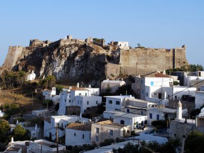
Below are some of the most impressive castles in Peloponnese you can admire

Acrocorinth - Ακροκόρινθος

Point for More
Acrocorinth is a monolithic rock overseeing the ancient city of Corinth. It is the most impressive of the acropoleis of mainland Greece. The city's archaic acropolis, already an easily defensible position due to its geomorphology, was further heavily fortified during the Byzantine Empire as it became the seat of the strategos of the thema of Hellas and later of the Peloponnese. Afterwards it became a fortress of the Frankish Principality of Achaea, the Venetians and the Ottoman Turks.
Direction

Acronauplia - Ακροναυπλία

Point for More
The Acronauplia is the oldest part of the city of Nafplion in Greece. Until the thirteenth century, it was a town on its own. The arrival of the Venetians and the Franks transformed it into part of the town fortifications. Later, part of it was used as a prison until the Greek government decided that the view provided from its location would benefit the local tourism and built a hotel complex which still stands there today.
Direction

Bourtzi - Μπούρτζι Καρύστου

Point for More
Bourtzi is located in the middle of the harbour of Nafplio. The Venetians completed its fortification in 1473 to protect the city from pirates and invaders from the sea. The Greeks regained it from the Turks on June 18, 1822, from where they assisted in the siege of Nafplio. Until 1865 it served as a fortress. It was then transformed into residence of the executioners of convicts from the castle of Palamidi.
Direction

Chlemoutsi - Χλεμούτσι

Point for More
Chlemoutsi is a medieval castle in the northwest of the Elis regional unit in the Peloponnese peninsula. It was built in the early 1220s by the Crusader rulers of the Principality of Achaea as their main stronghold, and is perhaps the finest fortification of the early period of Frankish rule in Greece preserved in the country today. it was captured in 1460 by the Ottoman Empire, along with the rest of the Byzantine Despotate of the Morea.
Direction

Cythera - Κύθηρα

Point for More
The most important castle is the one of Chora, called "Fortetsa" built in 13th century on a great, strategic spot as from there the Venetians could look all ships that were going to, or coming from Crete.
Direction

Karytaina - Καρύταινας

Point for More
The castle was built during the Frankish occupation in the 13th century by the glorious French knight Geoffroy de Briel. He inherited Karytaina from his father Hugo. There are indications, however, that in the position preexisted a Byzantine and perhaps an ancient castle. In 1324, the commander of the castle was bribed by the Despot of Mystras Andronikos II Palaeologus and Karytaina was taken by the Byzantines. In 1460, Karytaina was conquered by the Ottomans.
Direction

Koroni - Κορώνι

Point for More
Koroni castle with impressive fortifications at the southwestern end of Peloponnese which existed since the 7th century AD and was completed and reconstructed by the Venetians in the 13th century. The city flourished in the following centuries, but it was constantly in the middle of the long conflict between Venetians and Turks. An ancient acropolis existed at the location of the castle since before the Trojan war.
Direction

Monemvasia - Μονεμβασία

Point for More
Monemvasia is a town and a municipality in Laconia, Greece. The town is located on a small island off the east coast of the Peloponnese. The island is linked to the mainland by a short causeway 200m in length. Monemvasia's nickname is the Gibraltar of the East or The Rock. While uninhabited in antiquity, the rock may have been the site of a Minoan trading post. The town and fortress were founded in 583 AD by inhabitants of the mainland seeking refuge from the Slavic and the Avaric invasion of Greece.
Direction

Mystras - Μυστράς

Point for More
Mystras, the 'wonder of the Morea', was built as an amphitheatre around the fortress erected in 1249 by the prince of Achaia, William of Villehardouin. Reconquered by the Byzantines, then occupied by the Turks and the Venetians, the city was abandoned in 1832, leaving only the breathtaking medieval ruins, standing in a beautiful landscape.
Direction

Tiryns - Τίρυνς

Point for More
Tiryns is a Mycenaean archaeological site in Argolis in the Peloponnese, some kilometres north of Nafplio. Tiryns was a hill fort with occupation ranging back seven thousand years, from before the beginning of the Bronze Age. It reached its height between 1400 and 1200 BCE, when it was one of the most important centers of the Mycenaean world, and in particular in Argolis.
Direction

Elea - Πύργος Ελαίας

Point for More
At the south side of the village, on a rock by the sea, there is a old watchtower. It was probably Frankish, built in the 13th or the 14th century.
Direction

Palamidi - Παλαμήδι

Point for More
The fortress was finished within a relatively short period from 1711 until 1714. The works were started by Morosini the conqueror of the city and were carried on till the last years of the Venetian occupation (1686 - 1715). It is a typical baroque fortress based on the plans of the engineers Giaxich and Lasalle. In 1715 it was captured by the Turks and remained under their control until 1822, when it was captured by the Greeks.
Direction

Kyparissia - Κυπαρισσία

Point for More
Kyparissia castle is also known as the Castle of Arcadia, which was the medieval name of the town. The Castle of Kyparissia was built by the Franks on the site of a previous Byzantine fortress. In the Byzantine period, a fortress was built in the place of the ancient acropolis. Later, when the Francs conquered Peloponnese in 1205, Arcadia became a property of the Prince of Achaea. “Arcadia ” was the medieval name of Kyparissia since the 10th or 11th century. The Francs rebuilt the old Byzantine fortress in the 13th century.
Direction

Methoni - Μεθώνη

Point for More
The castle of Methoni was built by the Venetians after 1209 at a strategic location, on a rock penetrating the sea and is separated from the land by an artificial moat. During the 4th century B.C. Methoni was fortified with more elaborately and remained autonomous until the imperial roman years, when it enjoyed the favour of some emperors. During the Byzantine years, it was still an important harbour and one of the major cities of the Peloponnese, and the seat of a bishop.
Direction

Patras - Πάτρα

Point for More
The Patras Castle was built around the mid-6th century above the ruins of the ancient acropolis by Byzantine emperor Justinian I after the catastrophic earthquake of 551, re-using building material from pre-Christian structures. In 1205, in the aftermath of the Fourth Crusade, it was taken over by the Franks, who strengthened it further, opening a moat on all three sides. The castle fell to the Ottoman Turks in 1458 and Venetians took the castle in 1687 during the Morean War, and kept it until the Morea was retaken by the Turks in 1715.
Direction

Palace of Nestor

Point for More
It is a central mansion of the Late Greek Age, surrounded by a fortified enclosure. Two-storey building that included storage areas, laboratories, baths, skylights, reception areas and central sewerage system and is located on the long hill of Epano Englianos. It is the best-preserved Mycenaean palace ever discovered. During his excavation, about 1,000 signs of linear B. were also identified.
Direction
[INSERT_ELEMENTOR id="10533"]